[ad_1]
Ten years ago, at 14:46 in the afternoon on March 11, 2011, the most powerful earthquake ever recorded in Japan occurred off the northeast coast of Honshu, the country’s main island.
It knocked Honshu an estimated 2.4 meters sideways and caused a tsunami that reached a maximum height of more than 40 meters and swept as far as 10 kilometers inland. The tsunami destroyed almost everything in its path and triggered the Fukushima nuclear power plant disaster. About 20,000 people were killed.
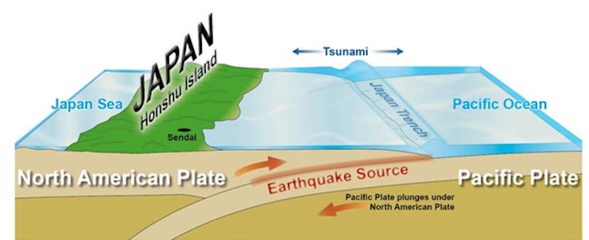
The Great Tohoku Earthquake was a magnitude 9.1 undersea megathrust earthquake resulting from the subduction of the Pacific Plate under the Okhotsk Microplate (an extension of the North American Plate) on which northeastern Honshu is located.
The Pacific Plate pushes beneath the Okhotsk Plate at a rate of 8 or 9 centimeters per year, building up an enormous amount of energy in the subduction zone, which is eventually released in slip-rupture type earthquakes. This particular quake caused the sea floor to rise by several meters. Hence the gigantic tsunami.
Our understanding of this geologic event was made possible by the insight and analysis of scientists who developed the theory of plate tectonics during two widely separated periods in the 20th century.
The first was the German explorer and scientist Alfred Wegener, who published his theory of continental drift in 1912. When he died in minus 60 degree temperatures after killing and eating his sled dogs during an expedition in Greenland, his theory had failed to gain credence and he was better known for his work in polar research and meteorology.
The continental drift theory was reformulated and accepted in the 1960s based on the discovery of seafloor spreading (the best-known example being the mid-Atlantic ridge), convection currents in the earth’s mantle (below the lithosphere, or outer crust, which is made up of several plates) and other evidence.
One of the scientists involved, and the one who subsequently did probably the most to promote the newly named theory of plate tectonics in the court of public and professional opinion, was Professor Seiya Uyeda of the University of Tokyo.
Uyeda’s book The New View of the Earth: Moving Continents and Moving Oceans (published in English in 1978 and now available here as a free PDF), helped popularize the theory by making it accessible to a broad audience.
My friend Richard Hook, who has worked as a petroleum exploration geologist in North America, North Africa, Central Asia, China and elsewhere, is a huge Uyeda fan.
“The New View of the Earth was significant for two reasons,†Richard told me in an email. First it was “well written and illustrated, clearly presenting the concepts that collectively became known as plate tectonics – an elegant theory elegantly explained; technically solid, but easily understood.â€
It was also timely. “In 1978, the concepts were very well understood by the researchers in the field, but not in the broad community of practicing geologists who had not been exposed to these concepts in university.
“As a newly graduated geologist working in Oklahoma City in 1980,†Richard said, “I was often asked by my senior colleagues to explain the theory of plate tectonics. I always referred them to this book – and they were uniformly impressed.â€
Today, the mechanism can be seen in maps and diagrams available on the internet and is in no danger of being pooh-poohed by the scientific community. And Professor Emeritus Uyeda – far from doing anything to canines that might bring him to the unfavorable attention of the Society for Prevention of Cruelty to Animals – has lived to the ripe age of 91.
Speaking of living, you probably had to live through the Tohoku quake to comprehend its magnitude. At the time the earthquake struck, we were nearly 400 kilometers away on the west coast of the Izu Peninsula. We arrived at a restaurant located high above the sea, our car rocking. Customers were running out the front door and kept going back in and running back out – my wife and I with them – until the aftershocks abated.
We thought that the earthquake was right below us, where the Philippine Plate collides with Honshu near Mt Fuji. The restaurant owner’s radio told us we had the right idea but the wrong plate.
Geologists Day will be celebrated on April 4 this year (the first Sunday in April, as usual). Established in 1966 by the Soviet Presidium, it is widely observed in Russia, other parts of the former Soviet Union and the People’s Republic of China, but is little known elsewhere.
This is a shame. Geologists Day will be a good opportunity to commemorate the accomplishments of Alfred Wegener, Seiya Uyeda and the numerous other scientists who have enhanced our view of the earth.
Scott Foster is an analyst with Lightstream Research, Tokyo.
[ad_2]
Source link


