[ad_1]
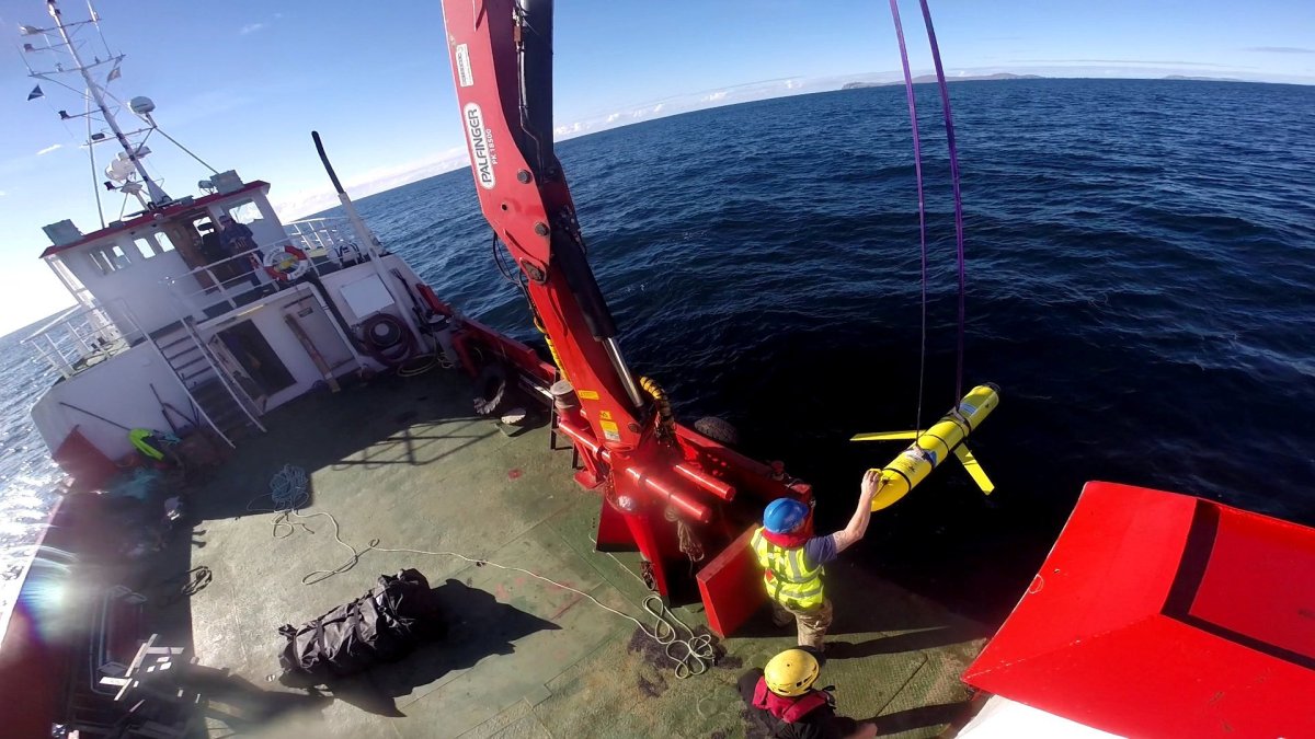
On December 20, 2020, an Indonesian fisherman off Selayar Island found himself in possession of a surprising catch: a 2.25-meter-long unmanned underwater vehicle (UUV). The slim yellow craft was a Chinese Sea Wing variable-buoyancy propelled glider, a long-endurance vehicle with sensors that can measure conductivity, temperature and depth in the underwater environment for both civilian and military purposes.Â
It was at least the third time Indonesian fishermen have recovered Sea Wings since early 2019. However, stranger things were to come. Far to the west, on January 19 this year, a mysterious 1.5-meter-long tubular metal object was found washed up on a beach in the Riau Archipelago. Its purpose was most likely to act as a sensor device and its Chinese-language markings indicate its Chinese provenance.
Earlier in January, Indonesian Coast Guard vessels in the Sunda Strait intercepted a Chinese survey ship, Xiang Yang Hong 03, that had turned off its transponder in violation of regulations. While Xiang Yang Hong 03 has sailed in Indonesian waters and the Indian Ocean before, its strange behavior has only heightened the suspicion that it is the source of the mysterious object recovered in Riau.
After all, another Chinese survey ship reportedly released a dozen Sea Wings in the Indian Ocean in December 2019, recovering them about two months later in February 2020.Â
India is familiar with the problem of Chinese survey ships. Last year, the Indian Navy turned back such a vessel after it entered India’s exclusive economic zone (EEZ) in the waters off the strategically vital Andaman and Nicobar Islands without prior permission from authorities.
The Chinese are not the only ones operating such UUVs in the Indo-Pacific region. In December 2016, the PLA Navy seized and later returned an American UUV in international waters near Subic Bay in the Philippines.Â
Major powers are investing time and money deploying UUVs in these waters because of the valuable oceanographic and hydrographic data they provide. Oceanography is the study of the physical and biological aspects of the oceans. Hydrography is the process by which the ocean bed is surveyed and navigation aids and charts are produced, providing ships the maritime equivalent of roadmaps and road signs.
Oceanography and hydrography have clear civilian applications: scientific research into climate and marine ecology, surveying the ocean floors to ensure safer navigation of merchant vessels, and collecting information for oil and gas or other seabed mining activities.
However, there are also equally clear naval applications: Hydrographic data ease the movement of naval surface ships. More important, they provide crucial information for submarines and for those tasked with hunting them. Over the coming years, the study of the oceans and the seabed is likely to become a source of power and influence in the Indo-Pacific region.Â
India will have no choice but to step up its game.Â
How India is mapping the oceans
The nodal government agency for hydrography in India is the National Hydrographic Office in Dehradun. The NHO’s main responsibilities are to conduct hydrography surveys with Indian naval vessels, provide navigation charts, issue area warnings and provide navigational safety information to mariners transiting their area of responsibility. This includes issuing area warnings during weapons tests and live firing exercises conducted by the Indian military.Â
India’s experience in hydrography also makes it a supplier of public goods in the region. The International Hydrographic Institute has designated the National Institute of Hydrography (NIH) in Goa as the regional hydrography training center for Africa, the Persian Gulf and Southeast Asia, opening an avenue for cooperation and increasing interoperability.Â
India has also signed memoranda of understanding with Indo-Pacific states such as Mauritius, Myanmar, Seychelles, Sri Lanka, Tanzania and Vietnam. Besides this, it has conducted surveys for Kenya, Mozambique, Maldives and Oman.
The Indian Navy currently operates eight survey ships with advanced hydrography sensors and scientific equipment onboard. These ships are crewed by a complement of specialist Indian naval officers and sailors who belong to the hydrography branch as well as civilian scientists who are affiliated with the NHO.Â
Some of these ships can deploy submersible autonomous drones to conduct their surveying activities. However, the details of which specific submersible drones, if any, is unclear. The lack of information suggests India lags far behind the US and China in fielding this key capability.
The way forward
To keep up with the increased obligations, four more large survey vessels are being built by GRSE (Garden Reach Shipbuilders & Engineers) shipyard in Kolkata for the Indian Navy. Like most Indian naval ships, they have been designed as multi-role utility vessels that can also double as hospital ships. These vessels would also be able to conduct search and rescue operations, carry disaster relief aid and evacuate people.Â
However, the central utility of these ships is as maritime domain awareness (MDA) platforms, especially under the seas. India has plans to expand its fleet of nuclear and conventional submarines over the coming decades.
A proportional investment in auxiliary and support platforms such as underwater scientific survey drones capable of conducting seabed mapping as well as auxiliary surface ships that can deploy, control and maintain them will be needed for these submarines to be operationally effective.Â
Given a significant lack of funds for capital acquisitions of ships, India would do well to build a derivative class of hybrid vessels. These should accommodate hydrography-scientific survey functionality as well as the ability to conduct minesweeping operations with submersible drones. India would do well to build such ships as a sustainable means of competing in the hydrography race under way in the Indo-Pacific region.
[ad_2]
Source link


